South Fork of the Cache la Poudre River
Cameron Peak Post-Fire Restoration


Project Overview
The South Fork was determined to be a high priority site to meet CPRW water quality objectives and US Forest Service values. This site ranked first in CPRW’s prioritization of over two dozen sites. It is located downstream of high severity burn areas within Wilderness designations that have not allowed for post fire mitigation. Therefore, large portions of high burn severity within the watershed have not received treatment following the Cameron Peak Fire. A small portion of the watershed, outside of Wilderness areas, was mulched following the Cameron Peak Fire. The combination of aerial and point mitigation treatments is a proactive strategy to improve water quality within severely burned watersheds such as those contributing to the South Fork. This site has been heavily influenced by not only the Cameron Peak Fire, but also past land uses (e.g., grazing) that have led to degradation of the riparian ecosystem. Additionally, analysis by JW Associates has shown water quality degradation through this reach following the High Park Fire.
Approximately 48% of the watershed contributing to this site was burned during the Cameron Peak Fire. The JW Hazard Assessment concluded that most of the Little Beaver Creek watershed was of highest hazard, and large portions of the South Fork above Little Beaver Creek were identified as high to moderate hazard. A hydrologic analysis was performed by Enginuity Engineering Solutions suggested that the post-fire flows would more than double compared to pre-fire flows for 10-year or less events due to the fire alone. This increased runoff will result in increased sediment and nutrient inputs from adjacent hillslopes to stream systems, thereby degrading water quality and aquatic habitat. The fire affected hydrology will also likely result in increased channel widening and downcutting, reduced floodplain connectivity, and impairment of ecological processes. While small portions of the watershed were mulched in 2021 and 2022, over 57% of the area contributing to this site are within USFS Wilderness boundaries that have not received post-fire mitigation.
Post-Fire Treatments
Log Structures – Large woody material, harvested off-site (gathered either from the adjacent Greeley property, private property along Fish Creek approximately 1 mile upstream of the site, or on approved Forest Service Land), was placed and interlocked in the channel to increase hydraulic roughness, reduce flow velocities, and enhance sediment deposition. Log Structures provide opportunity for sediment storage behind the structures while promoting aquatic habitat complexity and additional wood recruitment to the river system. They can also enhance nutrient uptake and riparian health by increasing groundwater exchange between the channel and floodplain sediments.
Post Assisted Engineered Log Jams (ELJs) – Post-Assisted ELJs are channel spanning structures constructed of large wood intended to slow velocities and deposit sediment while increasing groundwater connectivity and channel complexity. ELJs typically widen the channel over time, increasing connectivity and potential for long term wood storage. They can also enhance nutrient uptake and riparian health by increasing groundwater exchange between the channel and floodplain sediments. ELJs are used when location of the feature is important in achieving design goals and movement may reduce the desired results.
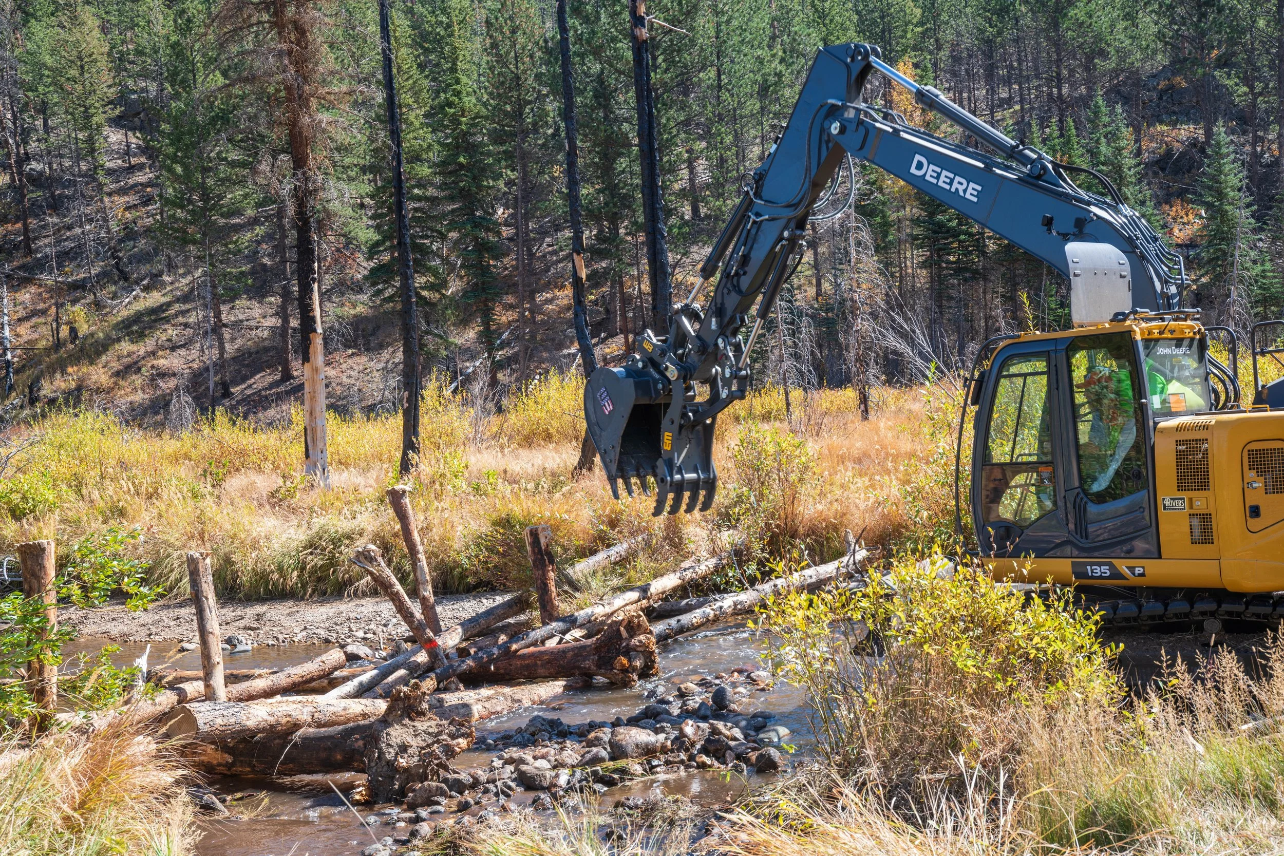
ELJs are constructed from logs gathered within the watershed. Woody material was collected either on private property along Fish Creek approximately 1 mile upstream of the site or on approved Forest Service Land. Each ELJ has two root wads and approximately six logs. Posts made from stripped trees were used to stabilize ELJs. Post and logs were installed using an excavator in the channel. When posts could not be vertically driven due to encountering shallow bedrock or large boulders, ELJS were converted to Log Structures.
Wood Roughness Feature – On-site large woody material was placed in the overbank areas to create roughness and opportunities for sediment storage, when inundated, and floodplain complexity. These features may be pinned with untreated posts or live plant cuttings to allow for long-term sediment storage and overbank complexity. Roughness features are placed adjacent to riparian planting areas to improve growing conditions and at meander bends to provide future wood recruitment.
Riparian Plantings - Recovery of riparian ecosystems is vital to improving water quality. Establishing woody riparian vegetation such as cottonwoods, willows, and other native plants increases the capacity for sediment storage and nutrient uptake and enhances habitat complexity in riparian and aquatic ecosystems. Narrowleaf cottonwoods and willows were gathered off-site and either planted as cuttings or as containerized stock after being grown in a greenhouse. These plants will be installed at locations with shallow water tables that will support establishment and continued colonization. Relative elevation models were used to identify feasible planting locations. Mass plantings of cottonwoods would restore gallery forest patches that are now scarce within the watershed. Willows would be installed near in-channel and floodplain mitigation features to provide additional hydraulic roughness and structure stability.
Proposed features were strategically placed at locations that will encourage surface and groundwater flow into historic alluvial flow paths whenever possible. In channel features will contribute to sediment deposition, nutrient uptake, and channel complexity while increasing wetland and aquatic habitat value.
Proposed features, such as these post-assisted engineered log jams, were strategically placed at locations that will encourage surface and groundwater flow into historic alluvial flow paths (Phot credit: Ayres Associates/Mike Laughlin).
Project Goals
Mitigation at this site will benefit Wild and Scenic recreation, fisheries, aquatic health, and aesthetic values upstream and downstream of the project reach. It is expected that multiple rounds of mitigation over several years are needed to reconnect the floodplain. Future work will be determined based on adaptive management and available funding.
Increase roughness using woody features to reduce channel incision and create complexity in the channel, riparian areas, and floodplain to improve the functioning condition of the reach
Increase sediment deposition behind woody features to improve water quality
Raise the alluvial water table and increase wetness on the floodplain to support characteristic riparian vegetation
Enhance nutrient uptake by increasing hyporheic exchange with channel and floodplain sediments
Provide recruitment of woody material in the channel and on the floodplain to contribute to long-term recovery of fluvial processes
Project Collaborators
U.S. Forest Service
Ayres Associates
AloTerra Restoration Services
FlyWater
Colorado State University (Research & Monitoring)
Funder(s)
Colorado Department of Public Health and Environment (CDPHE)
Colorado Water Conservation Board (CWCB)
Project Timeline
Completed Fall 2024

